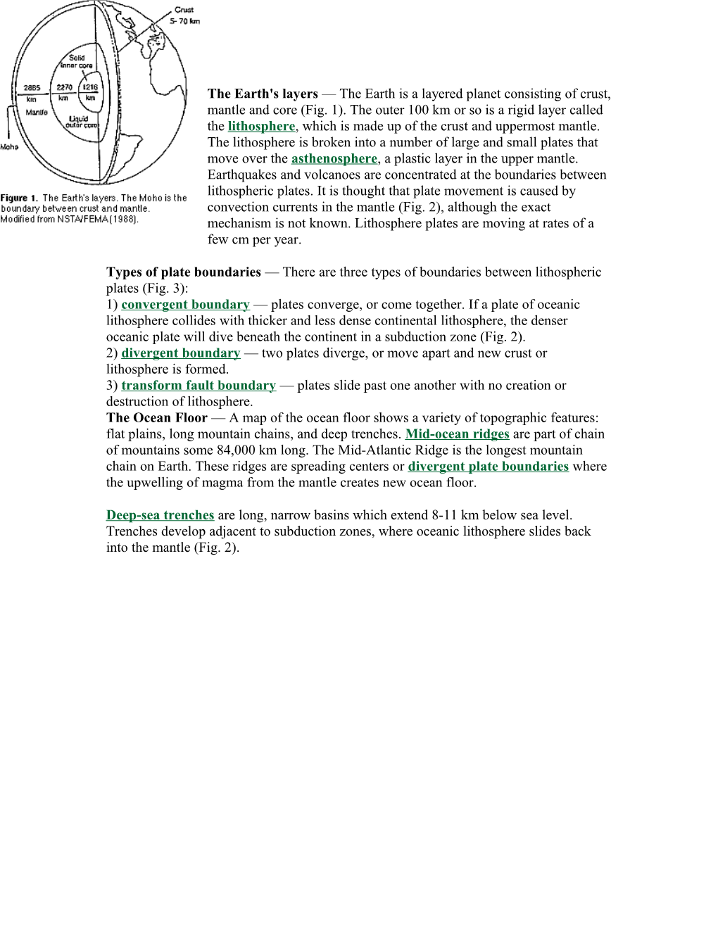
The Earth's layers — The Earth is a layered planet consisting of crust, mantle and core (Fig. 1). The outer 100 km or so is a rigid layer called the lithosphere, which is made up of the crust and uppermost mantle. The lithosphere is broken into a number of large and small plates that move over the asthenosphere, a plastic layer in the upper mantle. Earthquakes and volcanoes are concentrated at the boundaries between lithospheric plates. It is thought that plate movement is caused by convection currents in the mantle (Fig. 2), although the exact mechanism is not known. Lithosphere plates are moving at rates of a few cm per year.
Types of plate boundaries — There are three types of boundaries between lithospheric plates (Fig. 3):
1) convergent boundary — plates converge, or come together. If a plate of oceanic lithosphere collides with thicker and less dense continental lithosphere, the denser oceanic plate will dive beneath the continent in a subduction zone (Fig. 2).
2) divergent boundary — two plates diverge, or move apart and new crust or lithosphere is formed.
3) transform fault boundary — plates slide past one another with no creation or destruction of lithosphere.
The Ocean Floor — A map of the ocean floor shows a variety of topographic features: flat plains, long mountain chains, and deep trenches. Mid-ocean ridges are part of chain of mountains some 84,000 km long. The Mid-Atlantic Ridge is the longest mountain chain on Earth. These ridges are spreading centers or divergent plate boundaries where the upwelling of magma from the mantle creates new ocean floor.
Deep-sea trenches are long, narrow basins which extend 8-11 km below sea level. Trenches develop adjacent to subduction zones, where oceanic lithosphere slides back into the mantle (Fig. 2).
Continental drift — The idea that continents move is an old one; Alfred Wegener, a German meteorologist, proposed the hypothesis of continental drift. in the early 1900's. Wegener used several lines of evidence to support his idea that the continents were once joined together in a supercontintent called Pangaea and have since moved away from one another: (1) the similarity in shape of the continents, as if they once fit together like the pieces of a jigsaw puzzle; (2) the presence of fossils such as Glossopteris, a fossil fern whose spores could not cross wide oceans, on the now widely-separated continents of Africa, Australia, and India; (3) the presence of glacial deposits on continents now found near the equator; and (4) the similarity of rock sequences on different continents.
Wegener's hypothesis of continental drift was not widely accepted because he had no mechanism to explain how the continents move. The idea was not revived until new technology made exploration of the ocean floor possible.
Sea-floor spreading — In the early 1960s, Princeton geologist Harry Hess proposed the hypothesis of sea-floor spreading, in which basaltic magma from the mantle rises to create new ocean floor at mid-ocean ridges. On each side of the ridge, sea floor moves from the ridge towards the deep-sea trenches, where it is subducted and recycled back into the mantle (Fig. 2). A test of the hypothesis of sea-floor spreading was provided by studies of the Earth's magnetism.
The Earth's Magnetic Field — The Earth's magnetic field is thought to arise from the movement of liquid iron in the outer core as the planet rotates. The field behaves as if a permanent magnet were located near the center of the Earth, inclined about 11 degrees from the geographic axis of rotation (Fig. 4). Note that magnetic north (as measured by a compass) differs from geographic north, which corresponds to the planet's axis of rotation.
Placing a bar magnet beneath a piece of paper with iron filings on it will create a pattern as the filings align themselves with the magnetic field generated by the magnet. The Earth's magnetic field is similar to that generated by a simple bar magnet. At present, the lines of force of the Earth's magnetic field are arranged as shown in Figure 4; the present orientation of the Earth's magnetic field is referred to as normal polarity. In the early 1960s, geophysicists discovered that the Earth's magnetic field periodically reverses; i.e. the north magnetic pole becomes the south pole and vice versa. Hence, the Earth has experienced periods of reversed polarity alternating with times (like now) of normal polarity. Although the magnetic field reverses at these times, the physical Earth does not move or change its direction of rotation.
Basaltic lavas contain iron-bearing minerals such as magnetite which act like compasses. That is, as these iron-rich minerals cool, they become magnetized in the direction of the surrounding magnetic field. Studies of ancient magnetism recorded in rocks of different ages provide a record of when the Earth's magnetic field reversed its polarity.
During World War II, sensitive instruments called magnetometers were developed to help detect steel-hulled submarines. When research scientists used magnetometers to study the ocean floor, they discovered a surprising pattern. Measurements of magnetic variations showed that, in many areas, alternating bands of rocks recording normal and reversed polarity were arranged symmetrically about mid-ocean ridges (Fig. 5).
In 1963, F. Vine and D.H. Matthews reasoned that, as basaltic magma rises to form new ocean floor at a mid-ocean spreading center, it records the polarity of the magnetic field existing at the time magma crystallized. As spreading pulls the new oceanic crust apart, stripes of approximately the same size should be carried away from the ridge on each side (Fig. 5). Basaltic magma forming at mid-ocean ridges serves as a kind of "tape recorder", recording the Earth's magnetic field as it reverses through time. If this idea is correct, alternating stripes of normal and reversed polarity should be arranged symmetrically about mid-ocean spreading centers. The discovery of such magnetic stripes provided powerful evidence that sea-floor spreading occurs.
The age of the sea-floor also supports sea-floor spreading. If sea-floor spreading operates, the youngest oceanic crust should be found at the ridges and progressively older crust should be found in moving away from the ridges towards the continents. This is the case. The oldest known ocean floor is dated at about 200 million years, indicating that older ocean floor has been destroyed through subduction at deep-sea trenches.
It took exploration of the ocean floor to discover sea-floor spreading, the mechanism for the movement of continents that Alfred Wegener lacked. The hypothesis of continental drift gained renewed interest and, when combined with sea-floor spreading, led to the theory of plate tectonics.
asthenosphere — a portion of the mantle which lies under the lithosphere. This zone consists of easily deformed rock “Plastic like layer “
continental drift — Alfred Wegener’s hypothesis proposing large horizontal motions of continents. This idea has been replaced by the theory of plate tectonics.
convergent plate boundary — a boundary between two lithospheric plates that move towards each other. Such boundaries are marked by subduction, earthquakes, volcanoes, and mountain-building.
3 types: Oceanic/Continental; Oceanic/Oceanic; Continental/Continental
deep-sea trenches — long, narrow, and very deep (up to 11 km) basins oriented parallel to continents and associated with subduction of oceanic lithosphere.
divergent plate boundary — a boundary between two plates that move away from one another; Oceanic/Oceanic: new lithosphere is created between the spreading plates. On land,(continental-continental), diverging boundaries create a Rift Valley.
lithosphere — the rigid, outermost layer of the Earth; includes crust and uppermost mantle.
mid-ocean ridge — a continuous mountain chain on the floor of all major ocean basins which marks the site where new ocean floor is created as two lithospheric plates move away from one another.
normal polarity — a magnetic field that has the same direction as the Earth's present one. North is towards north pole,south is south pole
Pangaea or Pangea — the proposed "supercontinent" that began to break apart 200 million years ago to form the present continents.
plate tectonics — the theory that proposes that the Earth's lithosphere is broken into plates that move over a plastic layer in the mantle. Plate interactions produce earthquakes, volcanoes, and mountains.
reversed polarity — a magnetic field with direction opposite to that of the Earth's present field. North is towards the bottom of the earth where the South pole is now. South would be at the North Pole.
transform plate boundary — a boundary between lithosphere plates that slide past one another, create earthquakes
sea-floor spreading — a hypothesis, proposed in the early 1960s, that new ocean flooris created where two plates move away from one another at mid-ocean ridges.
subduction zone — a long, narrow zone where one lithospheric plate descends beneath another, rock is destroyed or recycled.